BOXES 120-121: Out West: Four Corners to Monument Valley.
- Joe Milicia
- Aug 7, 2021
- 5 min read

Updated: Aug 12, 2021

Monument Valley, on the Utah-Arizona border -- one of the most haunting of all American landscapes -- and if you love Western movies, one of the most iconic. This was a stop on the Western drive I was taking with Max and Gloria, as I've been reporting in the last several posts. It was pretty much 'on the way' from Mesa Verde National Park to the Grand Canyon.
But before showing more photos of Monument Valley, I'll start with the afternoon before, just after we left the Canyon de Chelly in NE Arizona, heading in a zigzag sort of way toward Mesa Verde in SW Colorado.
The Four Corners region, where AZ/NM/UT/CO meet in one point, contains some of the most rugged and even 'alien'-looking terrains we had ever seen, though human presence was marked by telephone or electrical wires and an occasional fence.


A mesa in the distance looked relatively 'ordinary' compared to other rock formations:

The most striking of all (I hope I'm speaking for the three of us) was Shiprock, an ancient volcanic 'neck.' We made a detour south into New Mexico to see this otherworldly sight:


Back at the exact Four Corners we naturally stood on the very point where the four states meet, though for some reason we didn't take the pictures of ourselves straddling the corners. (There was an official marker but not the extensive tourist center you can now see via Google Images.) I think the following photo of a Moon-like landscape was taken quite nearby:

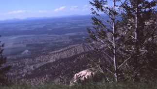
But soon we were inside Mesa Verde National Park, passing Point Lookout:

We camped inside the park, where Gloria took a photo of Max and me: I guess we're celebrating the fact that we'd found a good campsite. Mesa Verde is at a high elevation, and our heavy clothes indicate that the evening was cool and crisp.

We watched the sunset from our campsite:

The next morning we took in views of the distant mountains and close-by steep ridges . . .

. . . and signed up for a tour of the cliff dwellings that are the reason Mesa Verde is a National Park. While waiting at the gift shop for our tour to begin, we looked at items very far out of our price range, like this richly colored Navaho blanket:

. . . and these Hopi bowls (we had just been to the Hopi Reservation the afternoon before):

I'd forgotten the names given to the various cliff dwellings we visited that morning, but I've been able to identify some of the places I photographed through Internet searches. Here is our first glimpse of one of the ruins--I'm pretty sure it's the one called "Spruce Tree House," the third-largest dwelling:


These next shots are of "Cliff Palace," the largest of the communal dwellings of Mesa Verde--in fact, the largest ancient cliff dwelling in North America, with 150 rooms and 23 kivas; the square tower you see on the right is four stories high. (This village was built in the late 1100s/early 1200s but abandoned by 1300.)

In the next shots you are looking up at the narrow staircase leading up to Cliff Palace, and at its round tower; and looking down from Cliff Palace into the valley/canyon/gully below:


I especially like the next shot because of the way people are scattered about through the houses, in sunlight and shadow, giving a sense of scale to the buildings and rocks:

Inside the square tower and looking up, you could see petroglyphs:


Here are a few more shots of Cliff Palace, including one of the rock ceiling:


And here's a closeup of some masonry:

Next, our group is climbing up a ladder to see another dwelling. That's our ranger-guide leaning over the top:

And here's a closer view of our guide:

Finally, here are some miscellaneous shots, possibly out of order, since Spruce Tree House shows up again twice, along with three views looking out from one of the dwellings (I like the glimpse of snow-covered mountains in the third shot), and one of Max (not sure what he's expressing here):


That afternoon we left Mesa Verde, heading toward the Utah border. Here are some shots taken along the way--not the best, but I'll include them for the sake of full coverage:


Driving westward along the San Juan River we saw some very striking rock formations, including one called Twin Rocks, near a small town of that name:


We also had fine views of the cliffs along the river glowing in the early evening sun:


At this point we needed to find a campsite for the night. We did find a place along the river, called the Sand Island Recreation Area. The part of the site alongside the river was especially beautiful:


But there was absolutely nobody else there--which felt a little creepy after we'd been surrounded by a whole village of campers the night before at Mesa Verde. So we spread our sleeping bags and staked our tent closer to the highway, i.e., farther from the river. (I recall that area being deserted too, but the photo below from the next morning shows that a couple of other campers arrived at some point.) After setting up we drove back to the nearby village of Bluff where there was a general store to get something for supper. There wasn't much: we came away with a cut-up chicken and a large jicama. But that turned out to be fine. It was dark by the time we grilled the chicken, by flashlight, but whoever did the grilling did it to perfection: the chicken was delicious even without salt and pepper, and the jicama--something I had never seen or heard of, let alone tasted, but as a Californian Gloria was perfectly familiar with them--was an excellent crunchy complement.
We were settled in and asleep when a couple of cars playing very loud music pulled up and a bunch--a 'gang'?--of kids began partying. We had all seen too many biker-gang movies, not to mention Touch of Evil, to feel relaxed about this arrival, especially since we had already been feeling uneasy about the isolation of the campground. But eventually the 'intruders' left and we went back to sleep. Here's the campsite the next morning: I seem to have been the first one up:

But we hadn't read a sign right next to our campsite--maybe the one in the picture, though I recall a much larger sign nearby--warning campers to check the ground carefully for rattlesnakes and scorpions before setting up camp.
Anyhow, we'd gotten through the night, and the nearby hills were beautiful in the morning light:

Very close to the campsite were some ancient petroglyphs:


As we drove west toward Monument Valley the landscape became more dramatic:

The San Juan River at this point had cut a steep canyon though some bends in an area called the Goosenecks:

Here is the land as we came up from the Goosenecks overlook:

We continued to see natural 'sculptures' created by erosion, notably Mexican Hat:

And then we were in Monument Valley:


The images really speak for themselves:


But the next photo does call for a little comment. We were permitted, by the Navajo Nation whose land this is, to take a dirt road through the territory for especially scenic views, but we quickly realized that we needed something like a Land Rover to deal with the rocks and ruts. My shot shows a bit of the road, dimly, in the lower left. We were lucky to be able to back out of the drive without damaging the Olds.

Here are four more shots I took during out visit:


After that, it was a fairly direct route, southwest and then west, to the South Rim of the Grand Canyon. But that visit deserves a separate post, which I'll provide next time.


Comments